Road Infrastructure and Transportation
Santander and Cundinamarca, Colombia
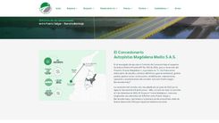
The case

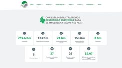
The client required a highly informative, publicly accessible website aligned with ANI standards to clearly communicate road conditions, project updates, and institutional policies. It also needed to offer customer service channels, PQRS queries, access to legal documents, real-time map integration, and internal communication channels such as video, radio, and print. The solution needed to operate seamlessly for thousands of users and organizations that access road corridor information daily.
The solution
EvolutecC designed and implemented a comprehensive digital solution that transformed the way the concessionaire communicates with its stakeholders. Key developments included:
-
A self-managed institutional website built on WordPress with a modular architecture.
-
A real-time road status consultation module with an interactive map.
-
A digital PQRS system that allows for anonymous and traceable submissions.
-
Integration of regulatory, environmental, and financial documentation.
-
Multimedia sections featuring TV programs, radio, institutional videos, and news.
-
Access to schedules for mobile offices and customer service lines.
-
SEO optimization and an accessible structure for both institutions and users.
-
High-performance Web development: EvolutecC designed a modular, highly scalable website with optimized infrastructure for high volumes of simultaneous traffic. The platform complies with the guidelines required by the ANI in terms of transparency, document management, environmental regulations and usability, allowing quick queries and intuitive navigation from any device.
-
Intelligent automation of critical processes: An automated PQRS management system was implemented, with automatic categorization, complete traceability and internal alerts, which reduced response times by more than 60% and strengthened the mechanisms for citizen attention in accordance with Law 1755 of 2015.
-
Operational autonomy and editorial efficiency: Thanks to a customized backend on WordPress, the client's team can manage key sections such as road status, official documents, news, multimedia and calls, without depending on the technical area. This has increased update frequency by more than 80% and significantly reduced digital management operating costs.
-
Geolocation and real-time road information: An advanced interactive map was integrated, fed with data categorized by type of event (works, accidents, incidents), which allows users to plan their routes based on updated information of the corridor. This functionality was developed with geolocation APIs and components.